
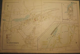
EATONTOWN, NEW JERSEY: 1873 MAP
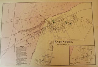
1873. [F.W. BEERS ATLAS OF MONMOUTH COUNTY]. EATONTOWN MAP, 1873. A 13-inch by 24-inch hand-colored map of Eatontown showing, Shrewsbury and Ocean Township. $75.00. More

1873. [F.W. BEERS ATLAS OF MONMOUTH COUNTY]. EATONTOWN MAP, 1873. A 13-inch by 24-inch hand-colored map of Eatontown showing, Shrewsbury and Ocean Township. $75.00. More
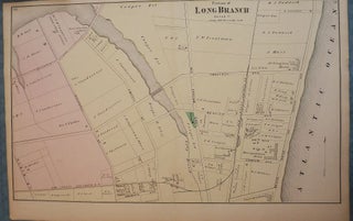
1873. [F.W. BEERS ATLAS OF MONMOUTH COUNTY]. LONG BRANCH, 1873 MAP. A 13-inch by 24-inch hand-colored map of a portion of Long Branch. $85.00. More
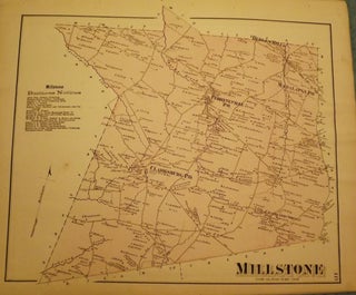
1873. [F.W. BEERS ATLAS OF MONMOUTH COUNTY]. MILLSTONE TOWNSHIP MAP, 1873. A 16-inch by 13-inch hand-colored map of Millstone. $75.00. More
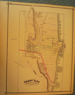
1876. PEASE, C.C. RIDGEFIELD TOWNSHIP/SHADYSIDE MAP. A one-page, hand-colored map of Shadyside & Ridgefield Township in Bergen County. From the original "Atlas of Bergen County" published in Reading, Pennsylvania by C.C. Pease in 1876. On the verso is a wonderful full-page engraving of the Traphagen, Hunter & Co. store in..... More
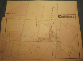
1876. PEASE, C.C. BERGEN COUNTY: CRESSKILL 1876 MAP. A large, hand-colored, fold-out map from the original "Atlas of Bergen County" published in Reading, Pennsylvania by C.C. Pease in 1876. The map shows Cresskill, Palisade Township from Chestnut Avenue east to County Road and from Maple Street north to Grant Avenue..... More
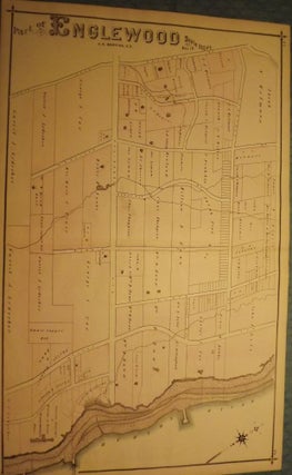
1876. PEASE, C.C. BERGEN COUNTY: ENGLEWOOD 1876 MAP. A large, hand-colored, fold-out map from the original "Atlas of Bergen County" published in Reading, Pennsylvania by C.C. Pease in 1876. The map shows part of Englewood form the Hudson River west to Jones Road and just South of Palisade Avenue north..... More
1876. PEASE, C.C. BERGEN COUNTY: FAIRMOUNT, NEW BARBADOES TOWNSHIP MAP. One small map and one large print from 1876. From the original "Atlas of Bergen County" published in Reading, Pennsylvania by C.C. Pease in 1876. One side is comprised of a 27.5-inch by 17-inch page showing a small map of..... More
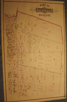
1876. PEASE, C.C. BERGEN COUNTY: HACKENSACK 1876 MAP. Three prints and one map from 1876. A large, hand-colored, fold-out map from the original "Atlas of Bergen County" published in Reading, Pennsylvania by C.C. Pease in 1876. One side is comprised of a 27.5-inch by 17-inch hand-colored map of part of..... More
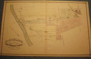
1876. PEASE, C.C. BERGEN COUNTY: KINGSLAND AND PART OF RUTHERFORD 1876 MAP. Three prints and one map from 1876. A large hand-colored, fold-out map from the original "Atlas of Bergen County." published in Reading, Pennsylvania by C.C Pease in 1876. One side is comprised of a 27.5-inch by 17-inch, hand-colored..... More
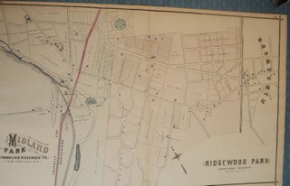
1876. PEASE, C.C. BEGEN COUNTY: MIDLAND PARK, RIDGEWOOD PARK, RIDGEWOOD TOWNSHIP AND WYCKOFF. Two small maps and one large map from 1876. A large, hand-colored, fold-out map from the original "Atlas of Bergen County" published in Reading, Pennsylvania by C.C. Pease in 1876. One side is comprised of a 27.5-inch..... More
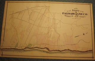
1876. PEASE, C.C. BERGEN COUNTY: PALISADES, PALISADE LAND COMPANY, HILLSDALE AND NORWOOD 1876 MAP. Two small maps and one large map from 1876. A large, hand-colored, fold-out map from the original "Atlas of Bergen County" published in Reading, Pennsylvania by C.C. Pease in 1876. One side is comprised of a...... More
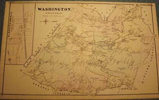
1876. PEASE, C.C. BERGEN COUNTY: WASHINGTON TOWNSHIP, HOHOKUS, PARK RIDGE, AND WESTWOOD 1876 MAP. Two small maps and one large map from 1876. A large, hand-colored, fold-out map from the original "Atlas of Bergen County" published in Reading, Pennsylvania by C.C. Pease in 1876. One side is comprised of a...... More
1889. [WOLVERTON'S ATLAS OF MONMOUTH COUNTY]. EATONTOWN MAP, 1889. A 20-inch by 30-inch hand-colored map of Eatontown, also showing Monmouth Park and Oceanport. Probably one of the best early maps of Eatontown ever made. $150.00. More
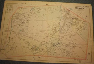
1889. [WOLVERTON'S ATLAS OF MONMOUTH COUNTY]. HOWELL TOWNSHIP, 1889 MAP. A 20-inch by 30-inch hand-colored map of Howell Township, showing West Farms, Fairfield, Farmingdale, Jerseyville, Turkey Blue Ball, Greenville, Runyons, Bethel and Squankum. $150.00. More
1889. [WOLVERTON'S ATLAS OF MONMOUTH COUNTY]. MILLSTONE TOWNSHIP 1889 MAP. A 20-inch by 30-inch hand-colored map of Millstone Township, also showing the Navesink section of Middletown Township. $150.00. More
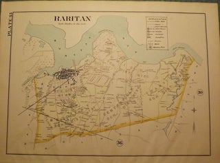
1889. [WOLVERTON'S ATLAS OF MONMOUTH COUNTY]. RARITAN MAP, 1889. A 15-inch by 18-inch hand-colored map of Raritan, showing the Union, Keyport, Bethany, Centerville, and Granville school districts. $50.00. More
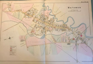
NY: Chester Wolverton, 1889. An original 30-inch by 22-inch linen-backed color map published in 1889. Map depicts Matawan. From Atlantic Avenue to the Matawan Creek; and from the railroad depot area to the Holmdel Turnpike area. Includes downtown areas. The original hand-colored map (Plate 28), not a reproduction! Wolverton maps..... More
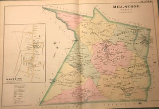
NY: Chester Wolverton, 1889. An original 30-inch by 22-inch linen-backed color map published in 1889. Map depicts Millstone Township from the Burksville area to the Mercer/Middlesex county border; and from the Upper Freehold Township border to the Manalapan Township border. Contains in set of the Navesink section of Middletown Township..... More
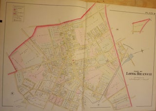
NY: Chester Wolverton, 1889. An original 30-inch by 22-inch linen-backed color map published in 1889. Map depicts Long Branch from the Atlantic Ocean to Pleasure Bay and from Broadway to the South Shrewsbury River. Shows types of structures erected at the time. The original hand-colored map (Plate 8), not a...... More
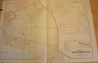
NY: Chester Wolverton, 1889. An original 30-inch by 22-inch linen-backed color map published in 1889. Map depicts Long Branch from High Street & Sixth Avenue to Myrtle Avenue; and from High Street to Joline Avenue. Shows types of structures erected at the time. The original hand-colored map (Plate 10), not..... More
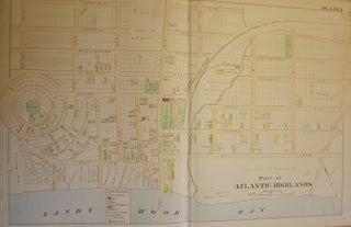
NY: Chester Wolverton, 1889. An original 30-inch by 22-inch linen-backed color map published in 1889. Map depicts Part of Atlantic Highlands, from the circular Prospect Park to Avenue D, and from Sandy Hook Bay to Garfield Avenue. Depicts types of structures erected at the time. The original map (Plate 3)..... More
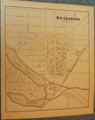
1878. [WOOLMAN AND ROSE ATLAS OF THE NEW JERSEY COAST]. BRICKSBURG, 1878. An 11-inch by 14-inch map of Bricksburg. $45.00. More
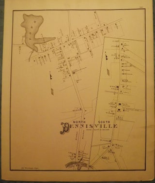
1878. [WOOLMAN AND ROSE ATLAS OF THE NEW JERSEY COAST]. DENNISVILLE, 1878. An 11-inch by 14-inch map depicting north and south Dennisville. $45.00. More
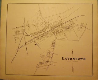
1878. [WOOLMAN AND ROSE ATLAS OF THE NEW JERSEY COAST]. EATONTOWN MAP, 1878. A 12-inch by 14-inch map of Eatontown. $45.00. More
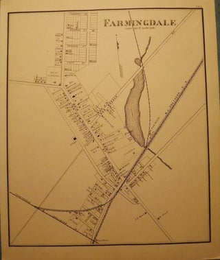
1878. [WOOLMAN AND ROSE ATLAS OF THE NEW JERSEY COAST]. FARMINGDALE MAP, 1878. A 12-inch by 14-inch map of Farmingdale. $45.00. More